


Meet Sirena Rana, Founder of Trails Inspire! Serena just published her book about the Arizona Trail (AZT) titled, "Best Day Hikes on the Arizona National Scenic Trail", which highlights 30 of the most scenic and accessible parts of the AZT.
We asked Sirena to share more about her journey to long trails, her book, and celebrating Arizona:

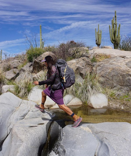
Like many in this state, I was not born here but I adore my adopted home. One of the best things about Arizona is the incredible variety of environments available for outdoor recreation. Want towering Saguaro cacti and exposed rock formations? Sky Island mountain ranges that rise thousands of feet from the valley floor? How about a hike through Ponderosa Pines, or the Wonder of the World that is the Grand Canyon? Arizona has it all.
One way to see it is to hike the Arizona National Scenic Trail (AZT), which spans 800 miles from Mexico to Utah. But you don’t have to do the whole thing to appreciate it – my new book, Best Day Hikes on the Arizona National Scenic Trail, highlights 30 of the most scenic and accessible parts of the AZT.

In 2007 I took a hike near the town of Oracle that changed the course of my life. I saw a sign that said “Arizona Trail” and read that an 800-mile trail was being constructed across the state. That hike led me to research and help build the trail. I hiked the AZT in sections over a period of 15 months in 2008-09 and what I saw absolutely blew my mind. Even though I’d lived in the state for 14 years prior to starting the hike, it gave me a newfound appreciation for the scenery, biological diversity and fascinating history.
I always say that the Sirena who started the trail was a completely different person than the one who finished it. That experience gave me confidence and sharpened my outdoors skills so that I could go on to do things I’d never imagined possible.
After that hike, I became the Gateway Community Liaison for the Arizona Trail Association for 5 years, promoting the AZT and connecting trail users to the towns along the trail. I thru-hiked the AZT in Spring of 2014 as a promotion for the trail and its communities, completing it for the second time after 2 ½ months. I have been asked again and again, “Which parts of the trail would you recommend?” This book is the answer to that question.

Each of the 30 entries in the book include in-depth route descriptions, navigational information, and detailed maps as well as full-color photographs, stories, and facts about the trail’s history and geography. The hikes include a Gateway Community guide with places to eat, stay, and more. Plus, there
are shorter versions of every outing—ideal for families and beginners.
The book has a guide to the 10 Essentials to carry on your hike, Desert Hiking Tips and Tricks, and information on Leave No Trace practices. As a child of immigrants in the Chicago suburbs, I didn’t grow up camping and hiking, so I wanted to use that beginner’s mindset to give folks the resources they need
to get on the trail. “[The book is] a perfect tie-in with our existing campaigns that educate visitors on how to travel safely during these times and how to care for Arizona’s amazing wide-open spaces,” said Debbie Johnson, director of the Arizona Office of Tourism. Arizona Tourism Hall of Fame author Roger Naylor provided the foreword to the book.
Also included is information about Ancestral Lands for each hike and an essay from Hopi archaeologist Lyle Balenquah, “Ancient Trails through Ancestral Lands.” Because even as we are celebrating Arizona’s statehood, we must remember that this land has been inhabited by Indigenous tribes for millennia.
I am very passionate about getting hikers onto the Arizona Trail and my goal is to empower people to take on their own adventures! To get your signed copy of the book or buy one as a gift, visit TrailsInspire.com/books. Share your adventures with the hashtag #DayHikesAZT for a chance to be featured on the @trailsinspire Instagram.
Please recreate responsibly and observe CDC guidelines when traveling and hiking. For more information about the Arizona National Scenic Trail, visit aztrail.org.
Arizona Trail Facts and Stats:
- 800 Miles from Mexico to Utah
- Connects deserts, mountains, forests, canyons, communities and people
- Multi-use trail for day hikers, backpackers, mountain bikers, equestrians, runners, cross-country
- skiers, snowshoers, photographers, birders, goat and llama packers and even the occasional unicyclist.
- Received National Scenic Trail status in 2009
- Connected across the state on December 16, 2011
- 3 National Parks: Coronado National Memorial, Saguaro National Park, Grand Canyon National Park
- 1 State Park: Oracle State Park
- 6 Wilderness Areas: Miller Peak, Mount Wrightson, Pusch Ridge, Superstition, Four Peaks, Mazatzal Wilderness
- National Forests: Coronado, Tonto, Coconino and Kaibab National Forests
- 33 Gateway Communities
- Crosses 9 major mountain ranges: Huachuca Mountains, Santa Rita Mountains, Rincon Mountains, Santa Catalina Mountains, Superstition Mountains, Four Peaks, Mazatzal Mountains, San Francisco Peaks
- Only National Scenic Trail in the U.S. to cross one of the 7 Natural Wonders of the World: Grand Canyon
You can order a copy of Sirena's book, Best Day Hikes on the Arizona National Scenic Trail here.


Leave a comment
All comments are moderated before being published.
This site is protected by hCaptcha and the hCaptcha Privacy Policy and Terms of Service apply.